Fitxategi:Map of the Kingdom of Galicia, 1914.jpg
Ez dago bereizmen handiagorik.
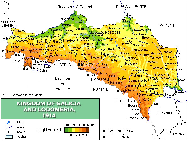
Map_of_the_Kingdom_of_Galicia,_1914.jpg (598 × 450 pixel, fitxategiaren tamaina: 157 KB, MIME mota: image/jpeg)
{{DVG|== Laburpena ==
| Deskribapena |
English: Map of the Kingdom of Galicia, 1914/Mapa fizyczna Galicji 1846-1918 |
| Data | |
| Jatorria | Norberak egina |
| Egilea | Mariusz Paździora |
| Beste bertsioak | image:Galicia physical1914-de.png German |

|
Irudi hau birsortu beharko litzateke SVG irudi bektorial moduan. Honek abantaila asko ematen ditu, ikus Commons:Media for cleanup (ingelesez) informazio gehiagorako. Irudi honen SVG bertsioa eskuragarri badago, mesedez Commonsera igo. Igo ostean, ordezkatu txantiloi hau txantiloi honegatik {{vector version available|irudiaren izen berria.svg}} irudi honetan.
|


Lizentzia
Nik, lan honen egileak, argitaratzen dut ondorengo lizentzia pean:
Fitxategi hau Creative Commons Aitortu 3.0 Unported lizentziaren mende dago.
- Askea zara:
- partekatzeko – lana kopiatzeko, banatzeko eta bidaltzeko
- birnahasteko – lana moldatzeko
- Ondorengo baldintzen pean:
- eskuduntza – Egiletza behar bezala aitortu behar duzu, lizentzia ikusteko esteka gehitu, eta ea aldaketak egin diren aipatu. Era egokian egin behar duzu hori guztia, baina inola ere ez egileak zure lana edo zure erabilera babesten duela irudikatuz.
Fitxategiaren historia
Data/orduan klik egin fitxategiak orduan zuen itxura ikusteko.
| Data/Ordua | Iruditxoa | Neurriak | Erabiltzailea | Iruzkina | |
|---|---|---|---|---|---|
| oraingoa | 07:13, 9 azaroa 2021 | | 598 × 450 (157 KB) | Alphathon | Corrected Bukovinan and Romanian borders |
| 09:02, 10 martxoa 2020 |  | 598 × 450 (310 KB) | Claude Zygiel | Kingdom of Poland was a part of the Russian Empire, kingdom of Hungary was a part of Austria-Hungary, and Galicia, Bucovina and Austrian Silesia were lands of the Austrian part. | |
| 18:40, 18 maiatza 2011 |  | 598 × 450 (193 KB) | VT | - Slovakia was not present then - Austria-Hungary was changed to Kingdom of Hungary: as the map shows several parts of Austro-Hungarian Monarchy, even Galicia, Bukovina and Austrian Silesia were the parts of it, not just Hungary. | |
| 18:01, 2 apirila 2008 |  | 598 × 450 (343 KB) | Kiejstut9 | {{Information |Description=Map of the Kingdom of Galicia, 1914 |Source=self-made |Date=2008 |Author= Kiejstut9 |Permission= |other_versions= }} |
Fitxategiaren erabilera
Fitxategi hau darabil ondorengo orri honek:
Fitxategiaren erabilera orokorra
Hurrengo beste wikiek fitxategi hau darabilte:
- bg.wikipedia.org proiektuan duen erabilera
- ca.wikipedia.org proiektuan duen erabilera
- da.wikipedia.org proiektuan duen erabilera
- de.wikipedia.org proiektuan duen erabilera
- el.wikipedia.org proiektuan duen erabilera
- en.wikipedia.org proiektuan duen erabilera
- es.wikipedia.org proiektuan duen erabilera
- et.wikipedia.org proiektuan duen erabilera
- fa.wikipedia.org proiektuan duen erabilera
- fr.wikipedia.org proiektuan duen erabilera
- gl.wikipedia.org proiektuan duen erabilera
- he.wikipedia.org proiektuan duen erabilera
- hu.wikipedia.org proiektuan duen erabilera
- it.wikipedia.org proiektuan duen erabilera
- ja.wikipedia.org proiektuan duen erabilera
- la.wikipedia.org proiektuan duen erabilera
- mk.wikipedia.org proiektuan duen erabilera
- nl.wikipedia.org proiektuan duen erabilera
- nn.wikipedia.org proiektuan duen erabilera
- no.wikipedia.org proiektuan duen erabilera
- pl.wikipedia.org proiektuan duen erabilera
- pl.wiktionary.org proiektuan duen erabilera
- pt.wikipedia.org proiektuan duen erabilera
- ro.wikipedia.org proiektuan duen erabilera
- scn.wikipedia.org proiektuan duen erabilera
- sh.wikipedia.org proiektuan duen erabilera
- sl.wikipedia.org proiektuan duen erabilera
- sr.wikipedia.org proiektuan duen erabilera
- sv.wikipedia.org proiektuan duen erabilera
- yi.wikipedia.org proiektuan duen erabilera
- zh.wikipedia.org proiektuan duen erabilera