Fitxategi:LocationRussia.png
Aurreikuspen honen neurria: 800 × 395 pixel. Bestelako bereizmenak: 320 × 158 pixel | 640 × 316 pixel | 1.500 × 740 pixel.
Jatorrizko fitxategia (1.500 × 740 pixel, fitxategiaren tamaina: 55 KB, MIME mota: image/png)
Laburpena
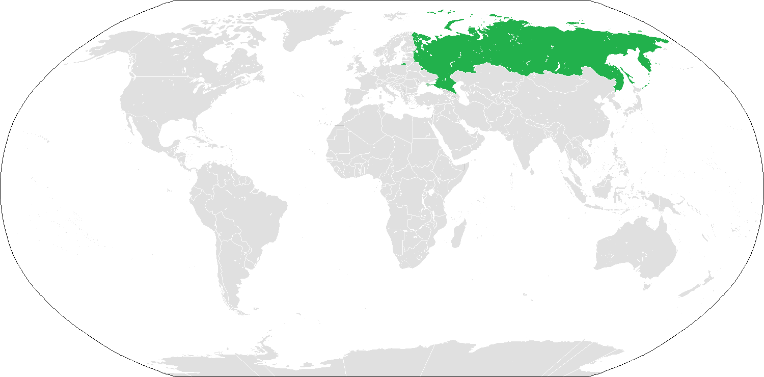
Location map for Russia. See also Image:BlankMap-World.png.

|
File:LocationRussia.svg fitxategi honen bektore bertsioa da. Hau rasterizatutako bertsioaren ordez erabili beharko litzateke hobea izatekotan.
File:LocationRussia.png → File:LocationRussia.svg
Grafiko bektorialei buruzko informazioa lortzeko, irakurri SVGra trantsizioa Commonsen. MediaWikiko SVG irudien inguruko laguntza teknikoa ere badago. |
 |
Lizentzia
| This work has been released into the public domain by its author, Vardion. This applies worldwide. Estatu batzuetan beharbada hori ez da legez posible izango. Halakoetan: |
Fitxategiaren historia
Data/orduan klik egin fitxategiak orduan zuen itxura ikusteko.
| Data/Ordua | Iruditxoa | Neurriak | Erabiltzailea | Iruzkina | |
|---|---|---|---|---|---|
| oraingoa | 06:44, 24 otsaila 2020 | | 1.500 × 740 (55 KB) | Xbspiro | Coloring of St. Lawrence Island had been changed (not part of Russia); removed shading on Antarctica (no Russian claim there) |
| 23:33, 31 abendu 2015 |  | 1.500 × 740 (55 KB) | Seryo93 | COM:CROP. Upload your file as a separate variant | |
| 18:40, 29 abendu 2015 |  | 1.425 × 625 (29 KB) | Consiglieri88 | Reverted to version as of 15:40, 15 February 2007 (UTC) | |
| 15:57, 10 otsaila 2015 |  | 1.500 × 740 (55 KB) | Leftcry | Update as per updates to the original map, Crimea disputed | |
| 15:40, 15 otsaila 2007 |  | 1.425 × 625 (29 KB) | Aivazovsky~commonswiki | ||
| 01:48, 9 ekaina 2006 |  | 1.427 × 628 (29 KB) | Aivazovsky~commonswiki | More detailed map | |
| 01:46, 9 ekaina 2006 |  | 1.427 × 628 (29 KB) | Aivazovsky~commonswiki | ||
| 12:36, 5 ekaina 2006 |  | 1.357 × 628 (27 KB) | Helmandsare | == Summary == Location map for Russia User:dbenbenn modified Image:BlankMap-World.png. == Licensing == {{PD-user-wikimedia|Vardion|en}} <!--Categories--> Russia [[Category:World maps indicating one | |
| 13:58, 23 ekaina 2005 |  | 1.357 × 628 (27 KB) | Green Ape | Location map for Russia User:dbenbenn modified Image:BlankMap-World.png. {{PD}} Category:Country locator maps | |
| 13:57, 23 ekaina 2005 |  | 1.357 × 628 (27 KB) | Green Ape | Update |
Fitxategiaren erabilera
Fitxategiaren erabilera orokorra
Hurrengo beste wikiek fitxategi hau darabilte:
- ar.wikipedia.org proiektuan duen erabilera
- ar.wikinews.org proiektuan duen erabilera
- قالب:روسيا
- إنهاء عمل وكالة الولايات المتحدة للتنمية الدولية في روسيا
- حريق في مشفى للأمراض النفسية في محافظة موسكو يودي بحياة 38 شخصاً
- فيلم «ذرة» للمخرج التركي أردم طبغوز أفضل أفلام مهرجان موسكو السينمائي الدولي
- والد إدوارد سنودن يحصل على تأشيرة دخول إلى روسيا
- ترانسنيستريا تدعو العالم إلى الاعتراف باستقلالها عن مولدافيا
- اكتشاف جديد للغاز في الجرف البحري القطبي لروسيا
- روسيا تستعد لتسليم سوريا دفعة من طائرات "ياك-130" بحلول نهاية 2014
- تصادم قطارين بضواحي موسكو يؤدي لمقتل 6 أشخاص
- موسكو: مستعدون لاستضافة المفاوضات "الفلسطينية-الإسرائيلية"
- تفجير يوقع عشرات القتلى والجرحى في روسيا
- روسيا تعرقل قرار بشأن الهجوم الكيميائي السوري
- غرق سفينة حربية روسية قبالة إسطنبول
- روسيا: مبادئ بوثيقة حماس تمثل خطوة في الاتجاه الصحيح
- روسيا توقف 650 ناشطاً تظاهروا ضد الحكومة
- مقتل أحد مستشاري وزارة الدفاع الروسية في سوريا
- روسيا تطرد 755 دبلوماسياً أميركياً
- روسيا: الحل العسكري لا يمكن أن يحل قضية كوريا الشمالية
- لافروف: واشنطن لن تقصف كوريا الشمالية
- طرد الوفد "الإسرائيلي" من اجتماعات الاتحاد البرلماني الدولي
- روسيا تطور "طائرة تاكسي" للنقل العام
- أربعة مليون روبل من روسيا للقضاء على شبكة تور
- روسيا تهدف إلى الإطاحة بعملة بتكوين الرقمية عن طريق إنشاء عملة رقمية خاصة بها
- القرم تحت حماية نظام أسلحة فريد
- avk.wikipedia.org proiektuan duen erabilera
- Teza:RossiaBost
- Teza:SibiriaMefta
- Alazeya (kuksa)
- Anabar (kuksa)
- Anadir (kuksa)
- Yana (kuksa)
- Uda (kuksa)
- Tcerski (jaka)
- Taymir (kuksa)
- Taz (kuksa)
- Stanovoy (jaka)
- Severnaya Dvina (kuksa)
- Indigirka (kuksa)
- Kamtcatka (kuksa)
- Kolima (jaka)
- Kolima (kuksa)
- Lena
- Mezen (kuksa)
- Nemunas (kuksa)
- Olenyok (kuksa)
- Oxota (kuksa)
- Penjina (kuksa)
- Petcora (kuksa)
- Pyasina (kuksa)
- Xatanga (kuksa)
Ikus fitxategi honen erabilpen global gehiago.